Day 1 - North Kawishiwi to Lake 4
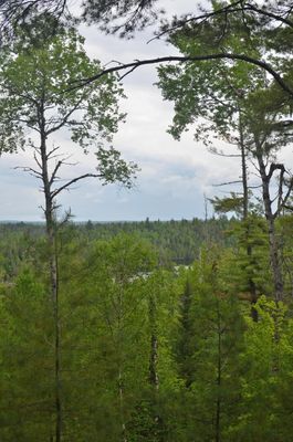
My original goal for the group was to make Hudson and stay on one of the North (unburned) sites. It was many in the groups first trips into the BWCA and the number of portages on the Kawishiwi really took their toll. I am used to coming in from Lake One, and it's easy to forget how many little portages there actually are East of there. Anyway, we made it in by late afternoon and stopped at a site I had visited in the past (but not stayed at.) The site was okay, but not phenominal. It was located in a small, unburned area in the vast expanse of Pagami so, considering that, it was a nice find. Firewood was plentiful and the tent pads were nice. This site is memorable because of the old chains anchored into the rock here. Maybe from an old fire grate back when they were installed that way, or maybe the chain is older still. Anyways, once the group was settled in, I hiked north to the next site marked on the map. It was located well within the burn area, and I knew it would have been heavily altered by that. I found the site (indicated by a large, open rock face and plenty of cut logs. There was no fire grate to be had. It seems the forest service had pulled it out and closed the site post Pagami. The group rested up for the next day.
Day 2 - Four to Fishdance
Our original goal for day 2 was to make it to Fishdance. Even though we had stopped on Lake 4 instead of Hudson, I still believed that to be an attainable goal, but we had to be efficient on Insula. I got the group up early, and we were on the water. We made it through the little portages on the way to Hudson and across Hudson without too much difficulty. Not staying on the sites I had wanted actually saved us about a mile of paddling besides. We encountered a pair of Eagles up close along the creek into Hudson, which was a really memorable experience for the group. The portage into Insula is always beautiful, but the berries were all running late this year (there were next to none to be had.) There was a strange, strong wind on Insula this day, so I took us along the North shore line (I usually stay further South) which was more protected. We ate lunch at another site I had been to in the past that has an amazing beach and is always a nice little break for the group. The creek through to Alice went well. Considering that portaging is not the group's strong suit, I was glad for lots of paddling this day. There was a tremendous wind on Alice which made me quite pleased to be turning off for Fishdance. The group was quite tired out by the final portage into Fishdance, resulting in lots of trips for me (and a capsized canoe), and we were worried when we were passed by a couple heading into the lake that our campsite would be gone. They continued on to one of the remote sites in the SW corner of the lake, leaving us the nice, clifftop site across from the pictographs. The pictographs truly didn't disapoint (so much better in my opinion than the Hegman or Crooked or Kawnipi ones I have seen in the past.) We were hit by a torential downpour shortly after dinner which pretty well sent the group to bed for the night. Fishdance is truly an incredible lake that added itself to my top five favorite lakes I have visted.
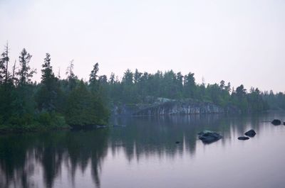
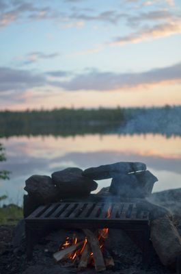
View from our Fishdance Campsite
Day 3 - Fishdance to Adams
Day 3 we had a shorter day planned intentionally for the group. The portages through this section definitely don't see a ton of traffic and are quite overgrown as a result. We had a mix of rain showers come throughout the morning, which guranteed getting soaked on the portages, but with scenery like this, who could mind? We ate lunch on Trapline and then made it to one of my highlights of the trip. The portage from Beaver into Adams is now my new favorite BWCA portage. It's hard to spot as it starts at the base of a large, granite cliff. The cliffs line both sides of the portage for its entire length. The first stretch is a really pretty Cedar swamp, the trails rises into a boulder field including a cave that still had ice in it when we visited (in June), there is a wonderful stone staircase, a huge field of ferns, and another huge rock face next to the landing on the Adams end. It truly was a beautiful walk. When we reached Adams, the island site I was hoping for was open and waiting for us. We ate lunch there and I left my group to fish and enjoy themselves while I headed out for a personal adventure. Over winter I admittedly spent a boderline unhealthy amount of time looking at BWCA maps and noticed a topographical odity on Smite Lake. There is what appears to be a huge bluff overlooking the North shore of the lake. I paddled over to Smite from Adams and, sure enough, there is quite the impressive geographical feature there. As I began the hike, it became apparant that reaching said height would be nothing short of a monumental feat. The area was all large, mature White and Red Pine which had been pretty severly impacted by the 99 blowdown and had become incredibly difficult to navigate since. I made it up to the high point just East of the largest high point, but couldn't safely go further solo without some unessecary risk. I headed back to camp for dinner and we were treated to an incredible sunset and a pair of Eagles in our campsite.
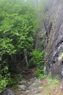
Beaver-Adams portage landing
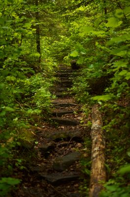
Staircase on the Beaver-Admas portage
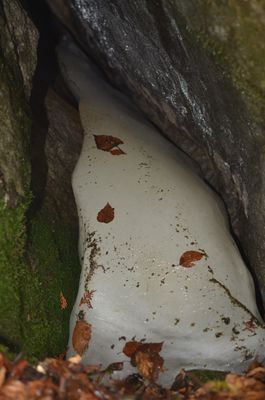
Ice in the cave on the Beaver-Adams portage
View from midway up the Smite high point - the ridge on Beaver is visible over a mile away
Day 4 - Adams to Hatchet
We headed out from our Adams site and worked our way North and then West. It was a challenging day navigationally for me since our Fisher map was nowhere close to accurate by this stretch (it had been struggling a fair amount since Fishdance.) The first portage of the day was marked as 10 rods (19 on Paddle Planner) and was marked as heading straight from the back bay of Adams into the beaver pond. After an hour of searching, we found nothing. I eventually in a state of frustration, began paddling the creek. Sure enough, it was navigateable. We never did find a 10 rod portage, but found ourselves at the 50 shortly after. I also knew that the 180 rod portage from would be confusing, and it did not disapoint. The beaver pond in the middle caused quite the confusion amongst the group for some reason, but we eventually made it through. At the end of the Cap-Roe portage, I and one of our other adults encountered a young bull Moose lounging in the river which was pretty spectacular to witness. After a morning worth of confusion, we ate lunch on Sagus. From there, it was smooth sailing through Fraser and Thomas and down the creek to Hatchet. The first site was full, but the second one was welcoming and open. Not the best site if there was a storm (two very prominant white pine lightning rods), but a really neat cliff face and camp kitchen made it a pleasant stay for us. We had another amazing sunset as a close to the day's adventure.
Campsite on Hatchet
Day 5 - Hatchet to Snowbank
Our final full day consisted of working through the little lakes to Snowbank. We made the obligatory stop at Cattyman falls before working our way to Abinodji for lunch. From there it was on to the Boot portage I had heard so much about. I was glad we were heading West, that portage would have really been a bugger the other way. We met our first really headwind of the trip on Snowbank and found our chosen site full. We backtracked a little to the site on the point of the big island that I had stayed at with a group last year. Not the best site, but it will make do. We stayed the night and reflected on the awesome trip. We paddled out the next morning to the Snowbank landing. Awesome trip that I will never forget.
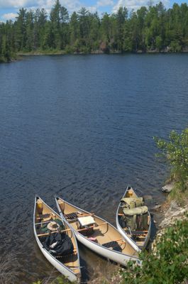
Canoes on Abinodji