 Thanks: 104 times
Was thanked: 181 time(s) in 157 post(s)
|
I added the burned areas to the Quetico map. I added all of the fires since 2005, though most of them are from 2021.
|
 2 users thanked Ben Strege for this useful post.
|
|
|
|
 Thanks: 39 times
Was thanked: 19 time(s) in 17 post(s)
|
I've been hoping that data might be possible to overlay like the BWCA. That's quite a bit of red...bittersweet for the obvious reasons of "what is good for the forest isn't always what I want to see in my lifetime." Thanks Ben!
|
|
|
|
|
|
|
|
I was glad to see it got added into the map. Will help with planning. Challenging part though is knowing the different areas of affect. Some areas we lightly burned and other areas were much more significantly burn. No way you can factor that in though. Just glad you got the outline of fires from last year for planning so thanks for getting it done. Ryan
|
|
|
|
|
|
Thanks: 104 times
Was thanked: 181 time(s) in 157 post(s)
|
As you alluded to, it is not a uniform burn area. Some areas were affected more than others. Hard to incorporate that into the maps here. I have seen this graphic making its way around the different paddling forums, and it is helpful: 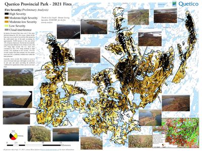
|
|
|
|
|
|
Thanks: 104 times
Was thanked: 181 time(s) in 157 post(s)
|
I figured out a way to overlay the fire severity map on the the Paddle Planner maps. I added a background option called "Quetico Fire Severity 2021." To use it, go to Settings, Map, and select the Quetico Fire Severity 2021 option. You can choose to turn the normal burn area layer on or off. It seems to work fine with the option on, and you can then see the fires from prior years. It is not perfect. The biggest issue I have right now is not being able to see the portages in the burn area. Another small issue is the shadow of the arrows I had to take out of the original image. Despite these two things, I am happy with how it turned out.
|
1 user thanked Ben Strege for this useful post.
|
|
|
|
| Users browsing this topic |
|
Guest (2)
|
Forum Jump
You cannot post new topics in this forum.
You cannot reply to topics in this forum.
You cannot delete your posts in this forum.
You cannot edit your posts in this forum.
You cannot create polls in this forum.
You cannot vote in polls in this forum.


